Another Arches National Park Trip

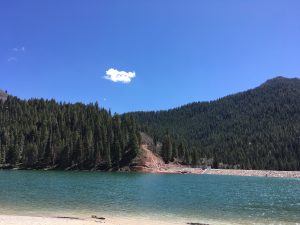
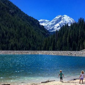
We have a few years long tradition of doing a weekend trip for my husband’s birthday. January is a hard month and having something to look forward to after the holidays has been very good for my mental health. Two years ago I booked a cheap condo at Bear Lake, and it ended up being so cloudy we couldn’t see the turquoise! We also had to cut our trip short due to an incoming snowstorm.

Last year we splurged on a, AirBNB right outside of Zion National Park. The location was ideal, the casita was super cute, and the park was empty. Empty! However, it also snowed and rained the weekend we were there, while the week before had been in the 60s.

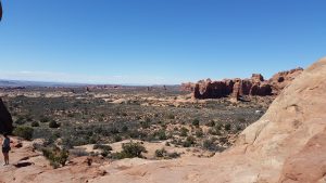
This year he requested Arches. We found an AirBNB that was nicer than the pictures indicated, and 15-20 mins from Arches’ visitors center. Moab is pretty empty in January as well and the park was pretty deserted. Part of this is due to the ridiculous government shut down, and part is due to the time of year. We’ve been to Arches a few times, but this was the first winter experience.

Day One

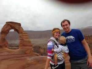
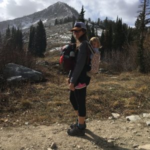
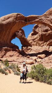
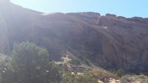
We stopped in the visitor’s center first to get some souvenirs, donate money, and chat with a ranger about conditions. My husband was most looking forward to hiking Delicate Arch, but the ranger advised against it due to ice. I have YakTrax but no one else has spikes, and the last little bit of that trail is a bit sketchy. I’m pretty risk averse these days so we chose some flat trails to experience. When our oldest was 18 months we hiked Delicate Arch with some family. I wasn’t into hiking at that point but have very fond memories of this one. My son was really fussy during the hike and so I waved the group on and sat on the side of the trail and nursed him. Then he fell asleep and I hiked with him strapped to my front the rest of the way. I got a lot of high fives and comments by people impressed by me, and I remember feeling proud of myself for figuring out how to make it to the arch with a baby.

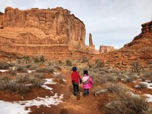
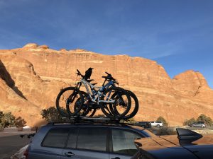
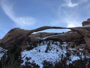
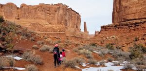
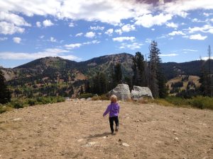
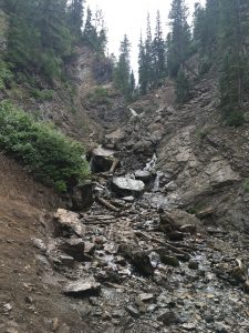
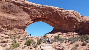
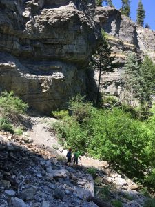
After the visitor’s center, we went straight to the Landscape Arch trailhead. This way we got to drive through the entire main road and see quite a bit. We parked at the Devil’s Garden trailhead and got our warm clothes on. It was around 35 degrees and there was snow and ice on the ground. Baselayers, fleece, hats, and gloves helped a lot (check my post if you need help figuring out winter clothing! Adults too.). Two massive ravens were perched on the rooftop bikes next to us, getting ready for a good time.

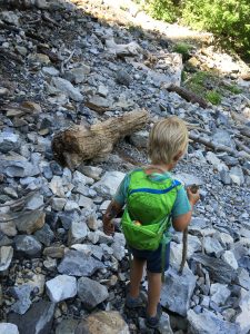
We hiked this trail three years ago when our kids were 3 and a few months shy of a year. I did put the sis on my back for a bit as the trail was super icy in spots. Because it is mostly flat I wasn’t concerned for our safety, and the kids genuinely enjoyed sliding around. It took us about half an hour to reach the arch, and we enjoyed the sunshine and the views and the red rocks before heading back to the car. This hike is under 2 miles round trip. We called it a day here and picked up pizza on the way to the AirBNB.

Day Two

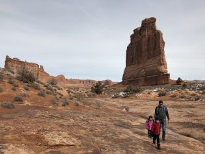
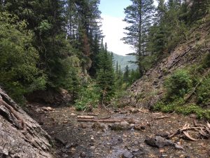
The next day we checked the weather and decided to leave that night instead of the following day as we had planned. A big snowstorm was headed through our route home this year again, and while we have snow tires, we didn’t want to be caught in a canyon with high winds and heavy snow. We reevaluated our ideas and decided to hike Park Avenue and then drive to the Delicate Arch viewpoint.

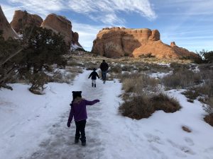
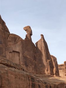
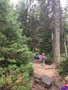
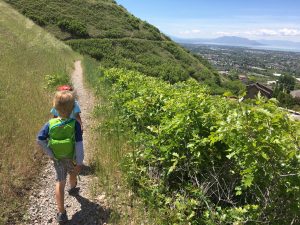
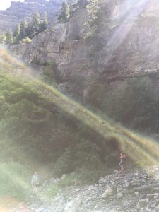
Park Avenue was so perfect for hiking with kids. Besides the descent into the canyon at the first of the trail, it is largely flat. While usually a pretty popular hike, we only saw two other humans. We walked along tall sandstone walls, admiring the way erosion has carved shapes from the canyon’s edges as well as the rock under our feet, and  seeing which small sandstone bowls were covered with ice. We had many opportunities to discuss staying on the trail, leaving no trace, and being so careful of the biological soil crusts. This hike is about 2 miles round trip and pretty easy.

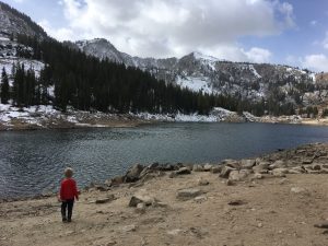
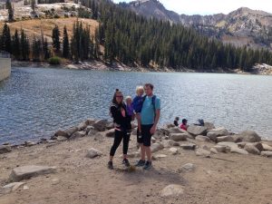
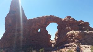
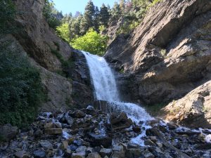
Next we drove to the Delicate Arch viewpoints and had lunch in the car. After eating we hiked up to the upper viewpoint for a better look at the arch. We did see several people around the arch but felt confident in our decision to not go without spikes. This hike is short and somewhat steep, but our three year old had no problem. We took some pictures and then headed out of the park.

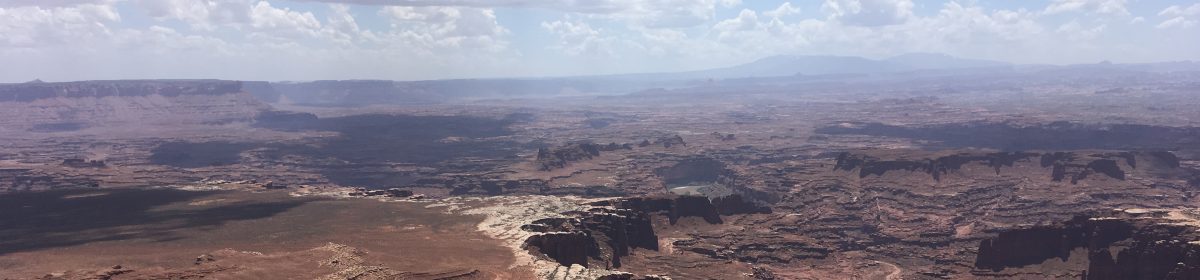
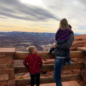
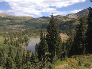
My favorite NP is Canyonlands, and my husband took us there as a last stop before heading home. Something about the salt edged lower canyons next to the river, the series of cliffs down to the valley floor fascinate me. I love it. We stopped at the Green River overlook for a few minutes and then called it a trip. Hopefully we can head back in less icy months to hike Delicate Arch.

Twin Lakes

Twin Lakes is one trail option that branches off from Silver Lake, the accessible one up at Brighton Ski Resort. Twin Lakes climbs above Silver Lake on a decently steep slope, presenting you with beautiful views first of the lake and then the surrounding valley. It is a fairly exposed hike, but the lake is really quite pretty.

OVERVIEW

Where: Brighton Ski Resort, starting from the back of Silver Lake

Grown up difficulty: easy to medium

Kid difficulty: medium to hard

Length and elevation: 760 ft up, 2.3 miles out and back

To see: lakes, trees, granite rocks

Busyness: medium to heavy

AllTrails: https://www.alltrails.com/trail/us/utah/twin-lakes

DETAILS

This hike starts at the back of Silver Lake. My post here covers Silver Lake pretty thoroughly. We’ve seen moose here on the boardwalk a few times, and the kids love to watch the fish in the water. At the backside of the lake, once you’ve hit dirt trail, there is a branch off for Twin Lakes and Lake Solitude. Twin Lakes heads to the left and Lake Solitude continues straight. Take the left branch, up the side of the mountain that borders Silver Lake.

This portion of the hike is quite exposed and the slope can be steep at times. If it’s near freezing, consider spikes and hiking sticks for your safety. You’ll hike through small boulder fields and evergreens, and get to see signs of ski season. Of course, the view is enhanced with the elevation gain, as the valley and mountains around Brighton are picturesque. Twin Lakes is a reservoir, so toward the end you’ll see signs of that, like metal railings around the edge of it.

At the lake, we like to explore a bit and have our snacks. The pines and firs around it bring a heavenly scent to the area.

REVIEW

This hike is one of the harder ones my kids have done. We’ve had a decent amount of whining with the combination of exposure and elevation gain. They love throwing rocks in the lake at the top, and you deserve a good break there after the climb (especially when you have to carry the snacks, water, and the child!). Use your distraction toolbox (friends, snacks, songs, games) and point out the different plants, animals, and bugs you see. If you can take friends along, do that!

Faves: the lakes, wildlife, trees

Hardest: exposure and climb

Gear: good shoes, snacks, water, possibly spikes and hiking sticks

Donut Falls

It’s been so hot in the valley that hiking is difficult. I know summer (especially high summer) is temporary, but avoiding sunburns and heat exhaustion is priority right now, while still enjoying the varying landscape. This week we went up to Donut Falls in Big Cottonwood Canyon. Due to morning swim lessons, we went in the afternoon, but thanks to afternoon thunderstorms the temperature was excellent.

We got to the trailhead around 12:30pm. This hike is easy and short with lots and lots of tree coverage. My 3.5 year old didn’t complain once, which was great because I ended up piggy backing my 6.5 year old after his shoe broke. This hike gets packed especially on weekends, so be prepared.

OVERVIEW

Where: Big Cottonwood Canyon, SLC. About halfway up.

Grown up difficulty: easy

Five year old difficulty: easy, as long as you start close to the actual trailhead

Length and elevation: AllTrails says 3.3 miles round trip, 550 ft gain

To see: foliage, river, waterfall

Busyness: BUSY. So so so busy.

AllTrails: https://www.alltrails.com/trail/us/utah/donut-falls-trail

DETAILS

Big Cottonwood Canyon is one of our favorite canyons. We go year round for hiking and for sledding and snow shoeing. This trail starts right before the Jordan Pines campground. There is a gate on the south side of the road that closes during winter. When it’s closed, your hike will start there. When the gate is open, drive through and park at the trailhead or anywhere close that parking is allowed.

There are a couple of hills at the beginning of the hike, but otherwise it is fairly flat. We worked on our flower identification and saw cow parsnip, monkshood, bluebells, asters, and twin berries. On the way to the waterfall, some red peaked out of the green bushes and we found wild raspberries!

At the end of the hike, you have to climb down some rocks (maybe 15 ft worth) to get to the river. We all sat on our butts as the rocks were wet from rain, and no one got hurt. Be careful here with littles. Then you walk along the riverbank until the trail ends. Cross the river (this time of year it was shallow and quite cold) to the opposite side, where a white placard is posted. We let the kids snack and play in the water here and didn’t climb further.

Alpine squirrels and chipmunks are all over this trail and they get super close to hikers. We didn’t feed them, but they tried to get into our packs when we set them down at the river. They can chew threw fabric so be aware!

I’m not comfortable taking my kids to the top, especially since I have fallen in a waterfall before, but tons of people do. The pictures look really neat.

REVIEW

This is a great little hike when you can start at the trailhead. Shaded, lots of foliage to point out (go in July if you want to see more flowers!), and waterplay. We made it there and back in about 2 hours, including a lot of time playing at the destination.

Faves: wild raspberries, waterfall, river

Hardest: climbing down to the river

Gear: shoes that can get wet, snacks, water, sunscreen

Choosing Battles

So. I have a three year old. Have you met three year olds? They’re called threenagers for a reason. My daughter has a strong personality and deeply held opinions, like wearing dresses and jelly sandals every day. Even when we hike. Maybe especially when we hike, because she can tell it bugs me.

This is a battle I’ve chosen not to fight. In fact, I made her wear her hiking shoes this week, and she got blisters. She’s been fine hiking in her jellies up until now, so the joke is on me. She also loves her ratty “beautiful princess dresses”. I’m letting it go, because she hikes just fine in them. They get dirty which she doesn’t like, but that’s a natural consequence I suppose.

She’s hiked herself to waterfalls, overlooks, and lakes in her jellies and dresses. And that’s what we’re working toward anyway, to have her strong and happy enough to hike herself and not go uppies. To spend time together in the wild.

All this to say, it’s okay to choose your battles when hiking too. For many reasons we don’t do intricate or technical hikes, and this allows a lot more freedom in choice for each of us. They’re learning to love the outdoors and the mountains together, and that is my ultimate goal.

First Aid

As I’ve mentioned, I’m still a new hiker. I started just a few years ago with no childhood experience and am learning a lot every time. Sometimes it’s simple like “bring more snacks!” and sometimes it’s bigger.

Last week we went to Horseshoe Bend. It wasn’t geat for my anxiety-no rails and sheer cliffs with massive drops down to the river freak me out. My husband is a good sport and helped the kids experience the views while I focused on breathing. The “what ifs” flood my brain in situations like that.

A couple weeks ago, I was the only adult at our neighborhood park when a kindergartner fell off his scooter and sliced a big chunk off his chin. Blood was everywhere, he was panicking, and the other kids were in shock at the sight. Thankfully after some pediatric plastic surgery, he was fine, but I’ve been thinking about that since. What if a similar accident happened while the kids and I were hiking? We could trip over rocks or felled trees so easily. I don’t habitually hike with any first aid kid, though we have two in our car, and my first aid training is super out of date.

The anxious part of my brain tries to convince me that staying inside, avoiding adventures and risk, will keep us all safe. Logically, I know that’s not entirely true and that if I listened to my anxiety, it would be at a big risk to the rest of our brains.

That said, I’m more determined to keep my first aid kit on me while we are hiking, and to take a refresher first aid class and/or get a wilderness specific first aid book. Hopefully with some planning, we avoid anything catastrophic. If you have any course recommendations, let me know. REI offers some (pricey) classes sponsored by NOLS, the Red Cross also has some, as does Wilderness Medicine of Utah,and I’ve seen some books that may be interesting. If I find more info, I’ll update this post.

Tibble Fork Reservoir

One of my favorite parts about Utah is the landscape diversity. We love the mountains around us, and those mountains bring lots of lakes, rivers, and streams. Sundays are often slower days (but not always, and not recently), and we love to get out as a family then. This last weekend we headed up to Tibble Fork Reservoir in American Fork Canyon.

Within the last couple of years, a new dock and a decent sized sandy beach were added to the dam. The water is always cold due to snow run off, but it’s a beautiful destination. Bring wind breakers and sunscreen!

We also checked out the Tibble Fork Loop trail, but turned back probably a mile into the hike. The trail was extremely narrow and tilted toward the water, and my kids don’t know how to swim yet. It was still a lovely jaunt through the forest. 

Special note-you do need a National Parks Pass or to pay for a 3 or 7 day pass to get in. Bring sand toys and check it out!

Arches National Park-Day Trip

It’s halfway through April and we woke up to three inches of snow. This past winter has been all over the place, and while I’m trying to embrace what is, I just can’t wait for warmer weather. Two years ago this month we took a quick day trip to Arches National Park. At the time we had a four and one year old, a somewhat unreliable car, and didn’t want to mess with bedtime out of our home. Day trip it was!

We scoured some pages on nps.gov and maps to see what we could fit in with just a few hours in the park. Our oldest had a limit of 2-3 miles at the time, but we wanted the 7 total hours in the car to be worth it. We left early in the morning with lunch and snacks packed, lots of water, and sunscreen.

Our first stop once we were in the park was Double Arch and The Windows Section. The total was around a mile and a half round trip to two beautiful, tall arches that touch on one end, and then up close to a couple window-like arches. It took us an hour or so, including hiking and gazing in awe.

Next we had lunch and then drove through the park while the 4 year old rested. The baby fell asleep, so we parked at the trailhead for the Sand Dune Arch. She and I waited in the car while my husband and oldest did this 20 minute, third of a mile hike together.

Our last stop was our biggest, an hour long hike to Landscape Arch. This was the toughest as my oldest had already hiked a couple miles and was hot and tired. We went slowly, letting him play in the soft sand and pause in the rare shade. This hike is around 1.5 miles round trip and we drank plenty of water during this one.

After our last hike, we hit up a Mexican restaurant in Moab and headed home. It was a lot of driving, but a great trip for our family at the time. Two years later my son still remembers the arches and wants to go back. Hopefully we can revisit this year and explore even more.

Gear

Bring water! We have a few hydration backpacks (Camelbak, Osprey) and water bottles (love my Hydroflask for hiking). Snacks and lunch, sunscreen, hats and sunglasses are pretty necessary in the desert. Good shoes too, as hiking in sand can be more demanding than harder surfaces. At the time my one year old was in an Ergo Ventus which worked great for her size.

5 Trails for When the Weather is Sketchy

This winter has had such weird weather. We’ve had a mostly mild one, but then the last couple of months the snow has dumped and melted, dumped and melted. The ups and downs have made for a high avalanche risk in the backcountry, and above certain elevations.

I’m not trained whatsoever in avalanche safety, so we’ve stuck to foothills and west/south facing trails, as well as paved ones. We have still been able to get outside for the most part, but have been playing it very safe. Here are some of our favorites! I’ll do individual, more detailed posts later, but this is a primer.

  1. Jordan River Trail. This paved trail is very close to our home, meanders along the river, and passes a remote control airplane park at the southernmost end. We’ve seen pelicans, cows, grass taller than us. I’ve heard there is a small set of hot springs at the very beginning of the trail, but we haven’t checked them out. We often start at Inlet Park in Saratoga Springs. 
  2. Utah Lake Parkway Trail. This  paved trail connects to the Jordan River Trail. It starts at North Lake Park in Lehi, in a small neighborhood. It passes fields, dense copses of trees, and abandoned structures. The hidden treasure though is the Utah Lake access trail. It’s short, unpaved, and super muddy. The mud is worth it (to me) to get down to the lake shore and get a nearly panoramic view of our valley. Bring something to deal with the muddy shoes after!
  3. Bonneville Shoreline Trail. Lake Bonneville existed until about 14,500 years ago. It covered the entire Salt Lake Valley and was about a third of the size of modern Utah. Because the lake existed for so long (it was formed around 500 million years ago!), significant deposits were left at various shorelines. The Bonneville Shoreline trail follows one of those. It has trailheads in most canyons throughout Utah County (I’ve started from Slate Canyon, Rock Canyon, east of Dry Creek Canyon). Use Google Maps to find a trailhead you want to use-the red pins are some options.
  4. Murdock Canal Trail. Another paved trail, this one sits atop the Murdock Canal. It’s pretty flat and open. Great for bikes, strollers, roller blades, wheelchairs, etc. There are trailheads from 800 N Orem to Highland Glen Park. Another one to use Google Maps for!
  5. Provo River Trail, of course. This busy busy paved trail is a favorite of many Utahns. It looks to start at the north east end of Deer Creek, go downhill through Provo Canyon, and follow the river all the way to Utah Lake. We usually use the portions around Bridal Veil Falls, the mouth of Provo Canyon, and near Fort Utah Park on Geneva Road. It’s usually well shaded, and it’s fun to watch the river change through the seasons.

What are your favorite places when getting up into the mountains isn’t an option?

Upper Falls, Provo Canyon

One of my hiking buddies noticed a waterfall a little east of Bridal Veil falls last year. She figured out how to get there and my kids and I tagged along. This pleasant hike is mostly flat, along the Provo River Trail. After a mile or so from the trailhead, a small path branches off behind a stone building. A brief climb takes you to Upper Falls, with great views of the canyon.

OVERVIEW

Where: Provo Canyon, starting from the bridge by the dam east of the Bridal Veil parking lot

Grown up difficulty: easy

Five year old difficulty: easy

Length and elevation: around 3 miles round trip with around 500 ft gain, depending where you park

To see: river, waterfall, cool rocks

Busyness: Provo River Trail is quite busy, but this branch off is not

Alltrails: https://www.alltrails.com/trail/us/utah/upper-falls

DETAILS

Provo River Trail is one of our favorite paved trails. There is a lot to see, especially with the river and waterfalls, and in the summer it is significantly cooler than the rest of the valley.

For this hike, you can make it longer (closer to 3 miles) by starting at the main parking lot for Bridal Veil falls and passing picnic areas. If you’re in a hurry, take the same exit, but drive the road that follows the river as far as you can. Cross the bridge, then hike east looking for a building covered in graffiti.

Behind the building is the dirt path that will take you to the waterfall. It is steep after this, but really short. We only saw 3-4 others on this part of the trail when we went.

There’s not really anywhere to sit and snack, but the water feels great during the hot summer, and my son loved checking out all of the different rocks.

REVIEW

Faves: waterfalls! My kids do great when a waterfall is the destination/

Hardest: the steepness

Gear: I need ankle support for steep hikes like this. Snacks, water, sunscreen will be helpful too.

Accessible Hikes: Cedar Hills Parkway

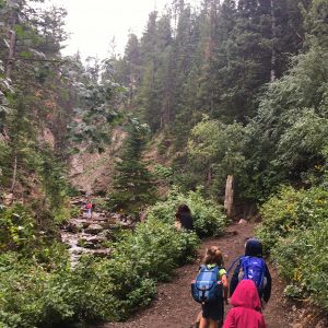
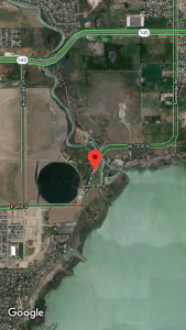
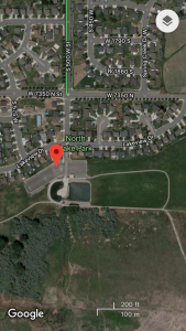
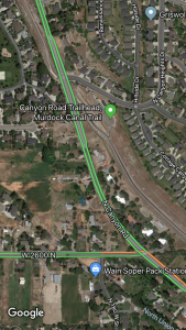
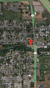
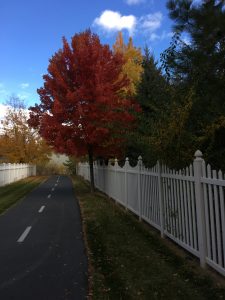
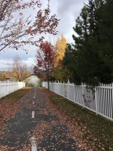
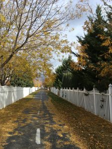
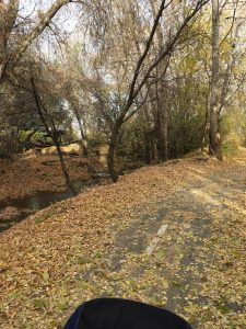
I stumbled upon this trail in the early fall. My daughter and I were in the area and had a couple of hours before needing to pick up my son from school, so I browsed Google Maps, found this one, and checked it out. Luckily it was a great shaded path!

OVERVIEW

Where: Cedar Hills with a couple trailheads, including one at the intersection of Cedar Hills Drive and Forest Creek Drive

Grown up difficulty: easy

Five year old difficulty: easy

Length and elevation: short or long, if you double back or if you walk over to the Highland Trails portion near the golf course

To see: trees changing through the seasons, the Pleasant Grove Ditch creek

Busyness: low

DETAILS

This is a stroller-, bike-, and wheelchair-friendly hike. It’s paved and shaded. There are a couple of playgrounds on the southern end of the trail, which I used as rewards for longer exercise.

Homes are fairly close to the trail, but with the creek and the shade it feels magical. Fall was such a treat and I watched the leaves change dramatically over a few weeks. If you’re not going for a full sweat, letting the kids search for treasures can be a super fun activity.

This is a really beautiful walk and a great option when you want or need a paved and scenic trail.

REVIEW

Faves: the quiet trove of nature within a residential community

Hardest: none

Gear: you choose! Walk, stroller, bike, blade, chair. I always bring water and snacks.